Discover the Exciting World of Immersive Maps
Are you ready for a whole new way of exploring and navigating? Get ready to embark on a journey through the immersive world of AI-powered maps. In this article, we’ll dive into the latest innovations that are revolutionizing the mapping industry. From visualizing routes like never before to providing developers with exciting new tools, AI is taking maps to the next level. So, let’s buckle up and get ready to explore!
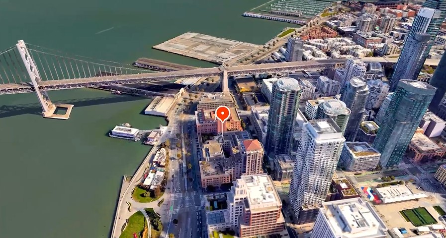
Immersive View for Routes: A Journey Like No Other
Prepare to be Amazed
Imagine being able to understand your route before even stepping out of your door. With Immersive View for routes, AI is making this possible. Whether you’re driving, walking, or cycling, this groundbreaking feature allows you to visualize every segment of your journey in advance.
The Magic of AI and Computer Vision
Immersive View brings together the power of AI and computer vision. By fusing billions of Street View and aerial images, a digital model of the world is created. This means you can access all the essential information about your route in one place, giving you a clear understanding of what lies ahead.
A Multidimensional Experience
Get ready to experience your route like never before. Immersive View lets you preview bike lanes, sidewalks, intersections, and parking spots along your journey. And that’s not all! With the time slider feature, you can also see how the weather changes throughout the day, ensuring you’re prepared with the right gear. Plus, AI algorithms simulate real-time traffic conditions, so you can anticipate the road ahead.
Exploring the World, One City at a Time
In the beginning, several of the world’s most intriguing cities will provide Immersive View for journeys. In places like Berlin, Dublin, Florence, Las Vegas, London, Los Angeles, New York, Miami, Paris, Seattle, San Francisco, San Jose, and Venice, you may soon embark on immersive experiences that take you from the picturesque canals of Amsterdam to the busy streets of Tokyo.
Empowering Developers: Unleash Your Creativity
Introducing the Aerial View API
Calling all developers! Get ready to take your applications to new heights with the Aerial View API. This powerful tool allows you to integrate captivating 3D birds-eye videos of specific locations into your apps. Now, you can provide users with stunning visual information about places, enabling them to explore neighborhoods virtually and make informed decisions. The possibilities are endless!
Photorealistic 3D Tiles via Map Tiles API
Customization is key, and Google Maps has got you covered. With the experimental release of Photorealistic 3D Tiles through the Map Tiles API, developers can unlock the full potential of high-resolution, 3D imagery from Google Earth. Whether you’re a tourism company showcasing national parks or a history enthusiast leading a virtual guided tour of a city, these photorealistic tiles will take your immersive experiences to a whole new level.
conclusion
Thanks to AI, maps are no longer just static images. They have become immersive, interactive experiences that bring the world to life. With Immersive View for routes, you can explore your journey before it even begins, while developers can unleash their creativity with the Aerial View API and Photorealistic 3D Tiles. The possibilities are endless, and the future of maps is brighter than ever. So, get ready to dive into the immersive world of AI-powered maps and discover a whole new way of exploring our beautiful planet.
Can I access Immersive View for routes in my city?
Immersive View for routes will initially be available in select cities, including Amsterdam, Berlin, Dublin, Florence, Las Vegas, London, Los Angeles, New York, Miami, Paris, Seattle, San Francisco, San Jose, Tokyo, and Venice. Stay tuned as more cities will be added in the future.
How does Immersive View for routes simulate traffic conditions?
Immersive View uses AI algorithms and historical driving trends to simulate the number of cars on the road at different times. This helps you get a realistic understanding of traffic conditions during your journey.
Can I customize the 3D maps using the Photorealistic 3D Tiles?
Yes! With the Photorealistic 3D Tiles via Map Tiles API, developers can create customized 3D maps using high-resolution imagery from Google Earth. It’s a fantastic opportunity to make your maps unique and engaging.
Are there any limitations to using the Aerial View API?
While the Aerial View API opens up exciting possibilities for developers, it’s important to note that it’s currently in preview. Make sure to check the documentation and guidelines provided by Google Maps Platform for the latest updates and information.
How can I get started with developing immersive experiences using Google Maps?
To start creating immersive experiences, visit the Google Maps Platform website, where you’ll find detailed documentation, APIs, and resources to guide you through the development process. Let your creativity soar and unlock the potential of AI-powered maps.
![ChatGPT Plagiarism Checker: Unveiling the Best Tools & Methods [June 2023]](https://thegptime.com/wp-content/uploads/2023/06/ChatGPT-Plagiarism-Checker-210x150.jpg)
![ChatGPT Fund: AI-Powered Investing [June 2023]](https://thegptime.com/wp-content/uploads/2023/06/ChatGPT-Fund-210x150.jpg)